Something like this would have been super useful as we went through this process last year! This is amazing! What I ended up doing was having to write up something that read through the NUTS III details and mapped them on google maps which wasn’t as detailed.
Would you be able to share what you used to generate this map image?
Hi all and thank you for arising this topic. It’s really unclear to understand the status of the place especially if you have a limited budget and wish to spend 280k.
I have checked the maps of @tkrunning and @pearlsofportugal , looked at PORDATA and would be appreciated if you can assist me with Resende area.
Resende is part of Tâmega e Sousa (NUT III), and part of the Viseu district.
GDP 2019/2020 is about 12k < 14k, So GDP is OK for 280k program
The population of Resende is 81.5 for 2021 So it’s also OK for 280k program
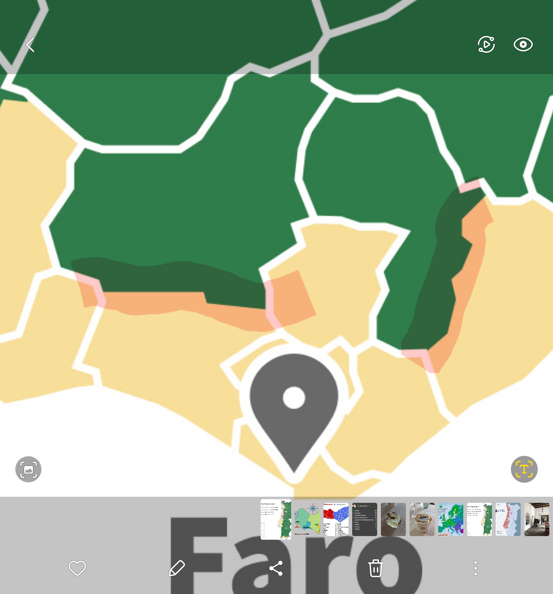
However, based on @tkrunning map I can invest in Viseu only for commercial projects. @pearlsofportugal’s website is also unclear with this info.
What do you think about it? Can I invest 280k to the property in Resende?
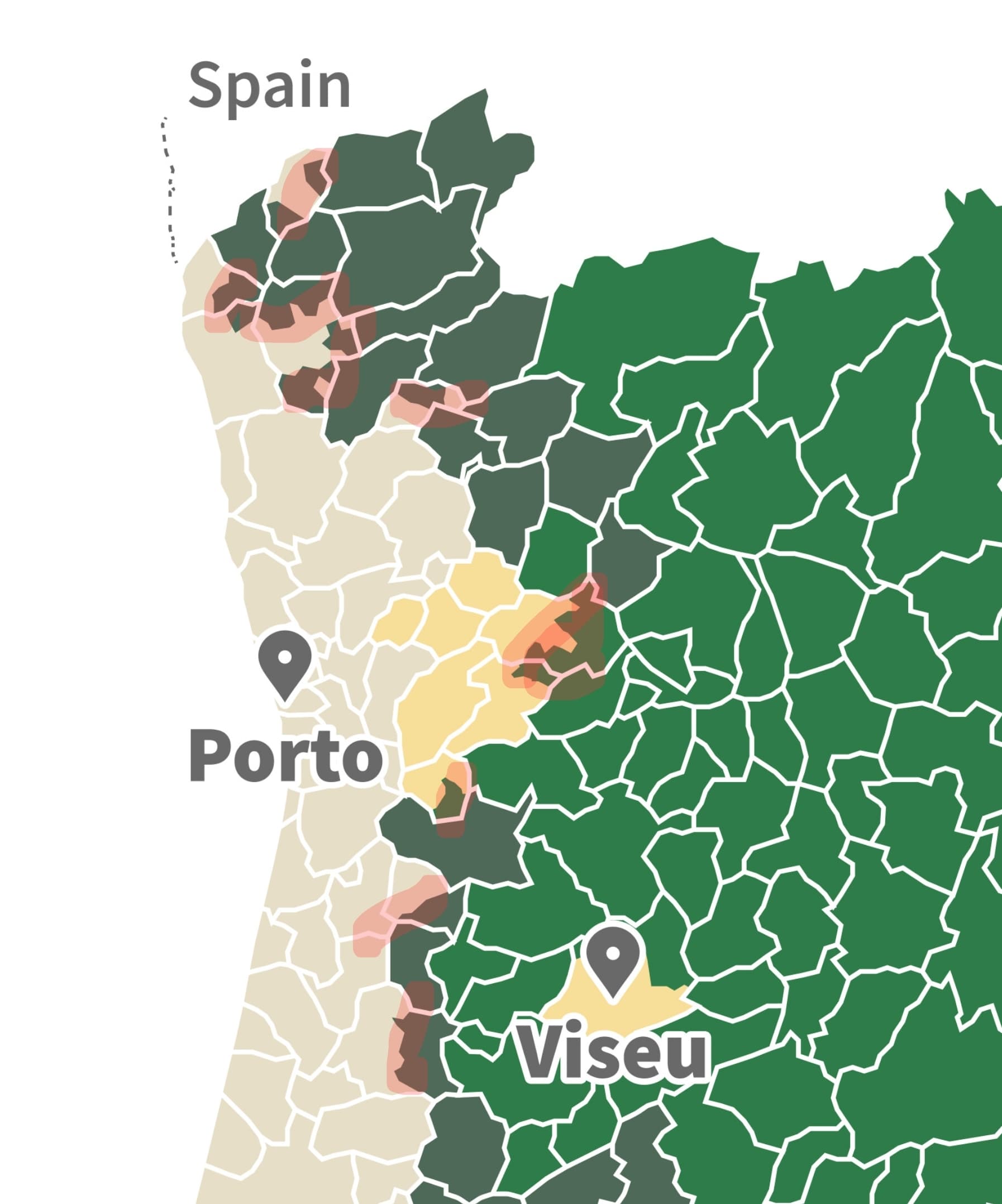
Hi @Alpine — the source of the confusion comes from thinking that the Viseu District is relevant for Golden Visa purposes.
The only thing that matters now is the parish (Resende), municipality (Resende), and NUTS 3 region (Tâmega e Sousa). Other subdivisions (which confusingly are often still used colloquially and even officially for other purposes) are irrelevant.
If you look closely at the map, the part around the city of Viseu that’s limited to commercial properties does not stretch to anywhere near Resende.
Still, it’s hard to really tell these things based on the map, which is why we built the search tool that gives you all the information you’ll need about a place in the context of Golden Visa property investments.
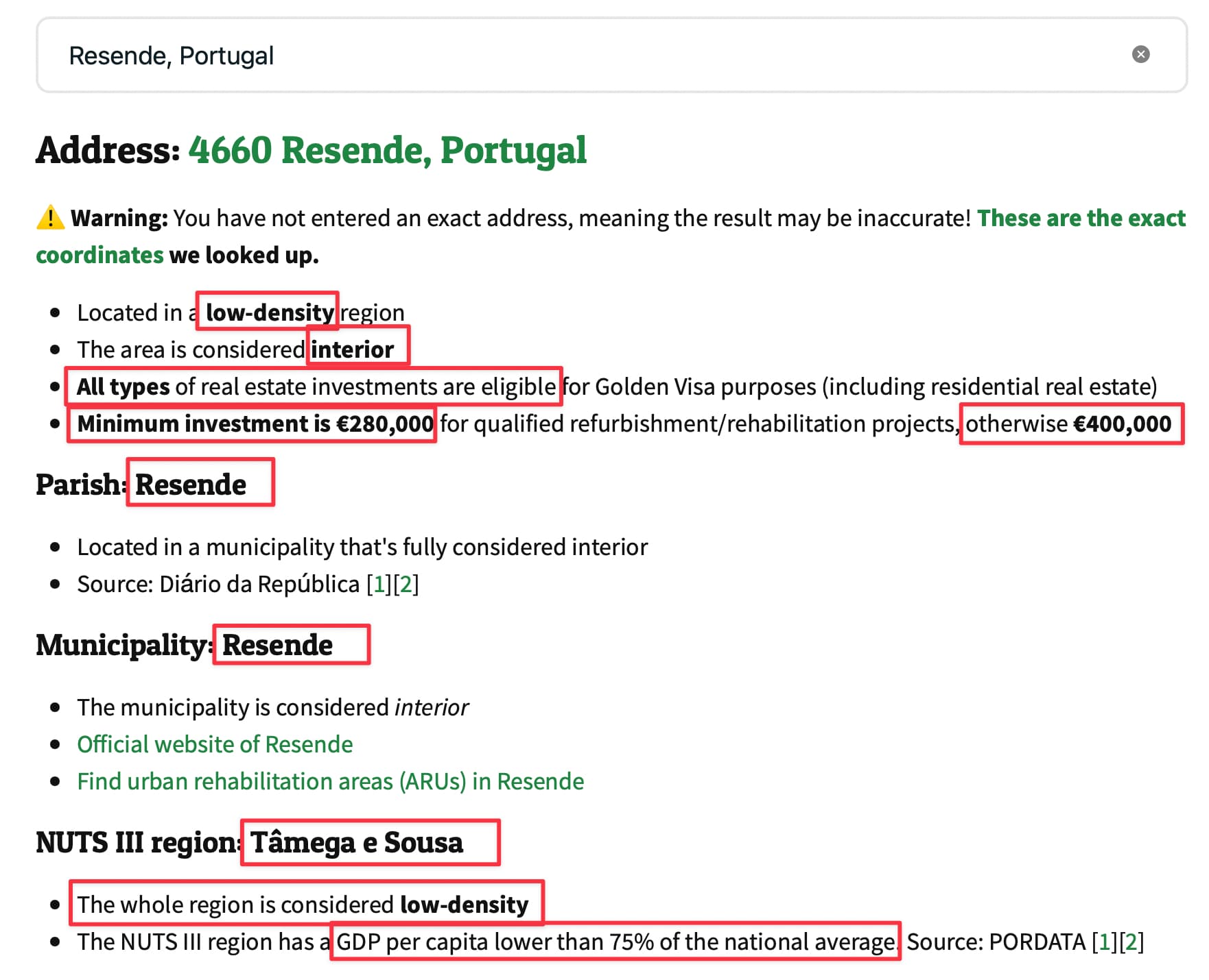
If you plug Resende into the tool you get this result (I’ve highlighted the important bits):
Yes, the GDP of the NUTS III region is lower than 75% of the national average, which automatically qualifies it as low-density
The population of Resende is irrelevant (it’s the population of the NUTS III region that matters), however the region anyway qualified based on GDP
Whether a specific property within Resende qualifies as 280K or 400K of course depends on the location and characteristics of the property. You can find the urban rehabilitation areas on the official municipality website, which is also linked from the search results.
@GVHope The sources are linked above, if that’s what you’re referring to:
If you are referring to how I turned that into a map, well that was by hand using Figma (based on an SVG file that had all the municipalities). The borders between parishes in the “mixed” municipalities were drawn by hand.
You can always use the map as a rough guide and if in doubt use the search tool to check specific parishes or addresses. The search tool’s list of parishes, municipalities, and NUTS III regions (and their exact coordinates) comes from this open source project by João Pimentel Ferreira.
I’m urgently searching for a property, and using the map you created. Problem is, it’s very hard to discern where the boundaries of Freguesias are. To remedy this, I hired a Google Map programmer to overlay the Freguesia boundaries on Google Maps. It’ll be much easier to look for properties, as you’ll see exactly where the borders are at. Some borders are running right down the middle of neighborhoods, I found this in Burgau! Using your lookup tool, an address on one side of the street is good, and the other side it is not available for the GV… Literally feet can make a huge difference.
I have the Freguesia SVG file with transparent background, got that off of Portugal | MapChart but you went the extra mile! Your map has boundaries drawn in several Freguesias which are divided, allowing purchases of residential properties in certain areas, and not in others. Specifically, Loule and Tavira near Faro, and several East of Nazaré and near Porto. If you could please share your file with me, I will send to you the Google Map with overlay as soon as he’s completed, hopefully tomorrow or the next day.
IIRC I based it off the Wikipedia SVGs, and it’s not accurate enough to distinguish one street from the next. It’s better to look up addresses you’re in doubt about here:
Oh I do that with every property, it’s just hard to determine when creating the search area on idealista, where that line is. If it gets me within a kilometer or so, that will dramatically help.
How did you know where to put the boundary within the parishes where residential real estate is allowed, and where it’s not allowed? That’s really the issue I am running into in in Loule and Tavira. As I want to be as close to the coast as possible, but not buy just over this line within those parishes.
@tkrunning here’s a video of the progress of the Google Maps Freguesia Project. As you’ll see, it’s incredibly accurate. Some of the boundaries you drew dividing Freguesias based on where you can and can’t buy GV properties, appears to be very complex, I’m sure you did not shoot from the hip. If you could share those, I will add that to the map project, as it will greatly help speed up the process identifying which properties that are potentially eligible. For properties pinpointed on either side of this border, we will double check those with your online search tool, to be 100% sure.
The blue pins are 35 properties pinpointed exactly where they’re at, which was very easy to do utilizing some good ol’ tradecraft. Not one estate agent was contacted to get the addresses/coordinates.
I used the Wikipedia SVGs for each municipality, as they are divided into each parish. You’ll find them on Portuguese language Wikipedia, not the English one.
Actually, I think for your purposes you should start with the “shapefile” you can download from here (it’s the first file listed):
It contains the official boundaries of each parish in Portugal in a format that should be more straightforward to convert to Google Maps than any SVG you’ll find on Wikipedia.
You can preview its data here (click on each region, and drill down to municipality, then click each municipality to drill down to the parishes):
I don’t recall how I did it exactly (it’s a while ago—just google how to open shapefiles in Google Earth) but here I’ve imported the shapefile into Google Earth:
We’ve already done that. We’re trying to figure out where you got the info to draw the areas within parishes where purchase of residential properties are allowed. Specifically Loule and Tavira are divided and we want to start there, then the parishes east of Nazaré and those up by Porto.
There are no divided parishes, only divided municipalities. The parishes I used are from Wikipedia as stated above, but the data should also be included in that shape file.
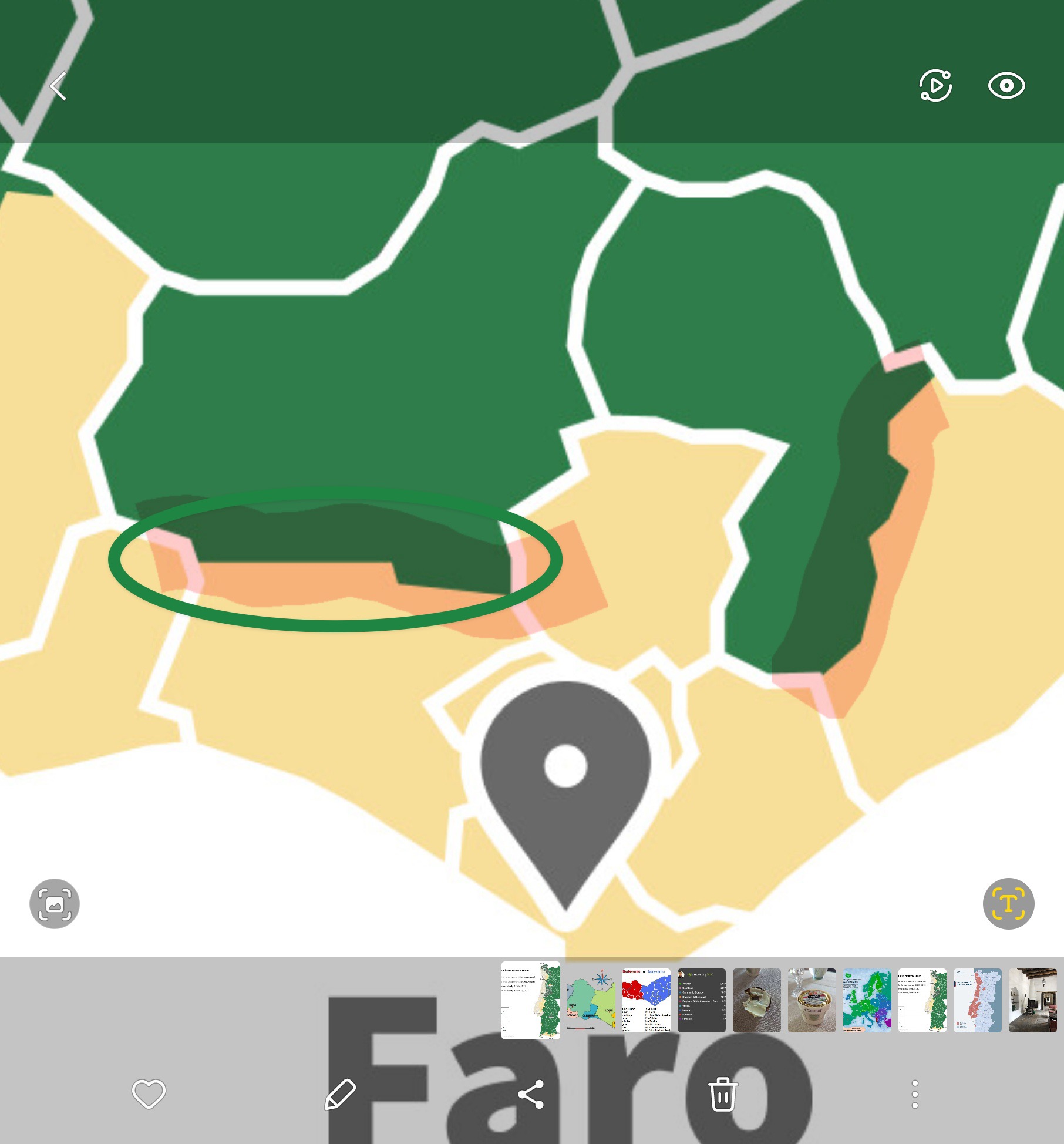
The white lines in my map are the boundaries of municipalities, the hand-drawn boundaries you marked are the boundaries between the relevant parishes in the few cases where the definition of interior vs exterior depends on a parish instead of the full municipality.
To add to the confusion, Loulé is also the name of the town/city, as well as a secondary official name of two of the parishes within the municipality of Loulé:


