I’ve been reading everything I can about getting the golden visa, and your community has been a great resource!
We’re currently in the stage of contacting advisors and lawyers to choose who to work with, and have gotten completely contradictory information from a few of them. Hoping some of you might have insight into these specific topics, which will in turn help me decide who to trust and move forward with!
Some state that a specific municipality we were looking into for real estate is low-density, while others say it’s high-density. I’ve been poking around the INE Statistics website and haven’t been able to find an official document listing high- and low-density areas. Anyone know where I can find one?
Do applicants need to go to Portugal before the SEF biometrics appointment? Two have said no, but another has said I need to visit Portugal before even beginning the process to provide “proof of legal entry” - and upon Googling that term, I see various sites mentioning it as necessary, but not elaborating on what it means.
Finally, some advisors say that the first residence card is good for 2 years. Another says that it was good for 2 years, but now that the initial COVID crisis has passed, the first card has reverted to the original 1 year duration.
Sorry if any of these are stupid questions. I’ve spent so many hours reading and Googling, and thought I understood the process until I started getting such contradictory information from the experts! Thanks in advance for any help.
Thomas wrote an article about this and there were also discussions here:
You should not need to go to Portugal before your biometrics appointment. We didn’t have to. I only had to show the required proof of legal entry to Portugal at my biometric appointment. It is basically showing them an entry stamp when you enter Schengen area. (They will ask for a boarding pass or itinerary if you got the entry stamp in another country before arriving to Portugal)
Based on my research, there is not a clear answer to this. The rules state that in 2021, the validity is 2 years. It is not exactly clear whether this means if you applied in 2021 or were approved in 2021. The implication to me is that if you apply in 2022, the period of the card will be 1 year but I cannot say for sure.
Thank you so much for this! It’s great to have it confirmed that we shouldn’t need to go there to start the process (and helps me cross that company off my list).
Thanks, too, for the links. I’ve actually seen that list before. Please correct me if I’m wrong, but as far as I can tell, that’s a list of the interior regions, meaning they’re eligible for residential investment—but not necessarily that they’re low density. It includes a lot of Região de Coimbra, for example, which it seems almost everyone agrees is high density.
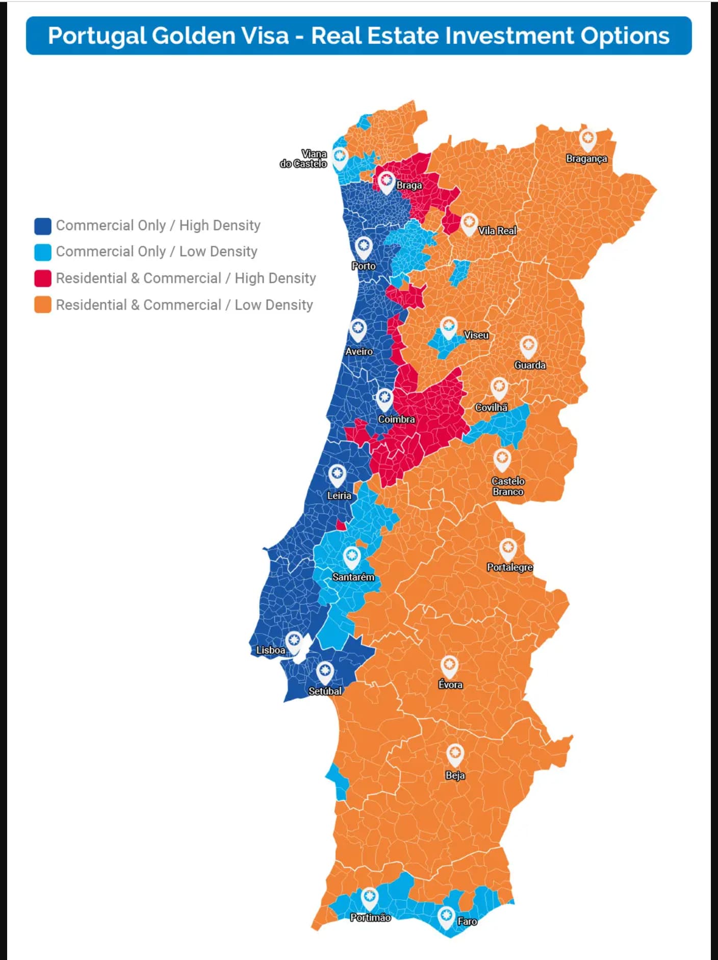
We’ve been looking around Arcos de Valdevez, which all the lawyers/advisors seem to agree is interior (and thus eligible for residential property) but can’t agree on whether it’s high- or low-density. Let’s see if this works… trying to attach four screenshots of maps, two of which indicate that Arcos de Valdevez is a high-density area and two of which indicate low-density. I’ve asked for clarification rather than just relying on these maps, of course, and answers are equally mixed.
Thanks, it’s good to know that I’m not the only one struggling to find a clear answer! In that case we’ll just plan for the first one being one year, and be pleasantly surprised if it’s two.
So, here’s a potential way to answer your question.
Article 65-A of DL 84/2007 as amended, paragraph 10, says that low density is defined as level III of the Nomenclature of Territorial Units For Statistical Purposes (NUTS III) of less than 100 people per sqkm, or GDP < 75% of national average.
This appears to be published by PORDATA, the stats unit.
That’s not the entire answer for GDP but the rest is left as an exercise to the reader, with all caveats applied.
Of course the map changes as new data comes in year for year. No doubt. Fun, huh? But that accounts for different maps from different sources - who drew the map when?
Please do not ask me why I am trying to answer this. Or even if I am right. but that’s how I read it. Once again I have let myself get sucked into reading Portuguese law (which is kind of like some mental jigsaw puzzle where any given piece will seem to fit with 20 other pieces though there is at the end of the day one right way, which is obvious once you manage to put enough of the pieces together to be able to see the picture enough to compare it to the box, but first you have to get that far) and stayed up far too late. Over something that isn’t even relevant to my life. Why do I do this?
This is amazing, and exactly the info that I wasn’t able to find despite hours of digging. I hope your career involves research, since you’re so good at it and it sounds like you enjoy it on some level!
Maybe part of the discrepancy in maps and answers is that while Arcos de Valdevez has just 46 people per square km, it’s within Alto Minho, which has 104. I can imagine some advisors might look at A. de V. and others look at Alto Minho. Who knows. With this info, I think we’ll play it safe and buy elsewhere—but I feel a lot better having a clearer sense of what’s going on. Thank you so much for your help with putting these particular puzzle pieces into place.
Well, even this is not the truly correct answer. The truly correct answer at any given moment is what’s on some document sitting around on an SEF agent’s desk, the contents of said document being some answers typed up by some SEF clerk who read the PORDATA web site at some point and published what s/he thought the right numbers were. Which version of the document the given SEF agent is reading for any given application might vary. And it is a shame they don’t just post the document so we can all agree on what it says. But they don’t, it seems, and at least a lawyer can argue your choice on a rational basis if it comes to that.
For what it’s worth, it seems clear they are going by the upper grouping (Alto Minho) not the municipality (Arcos de Valdevez), the former is in the NUTS III list the latter is not and the NUTS III list is quite explicitly controlling. So you’re out of luck.
Alto Minho was in wkb’s list anyway; none of the coastal provinces are eligible. That is also still controlling, as an added layer.
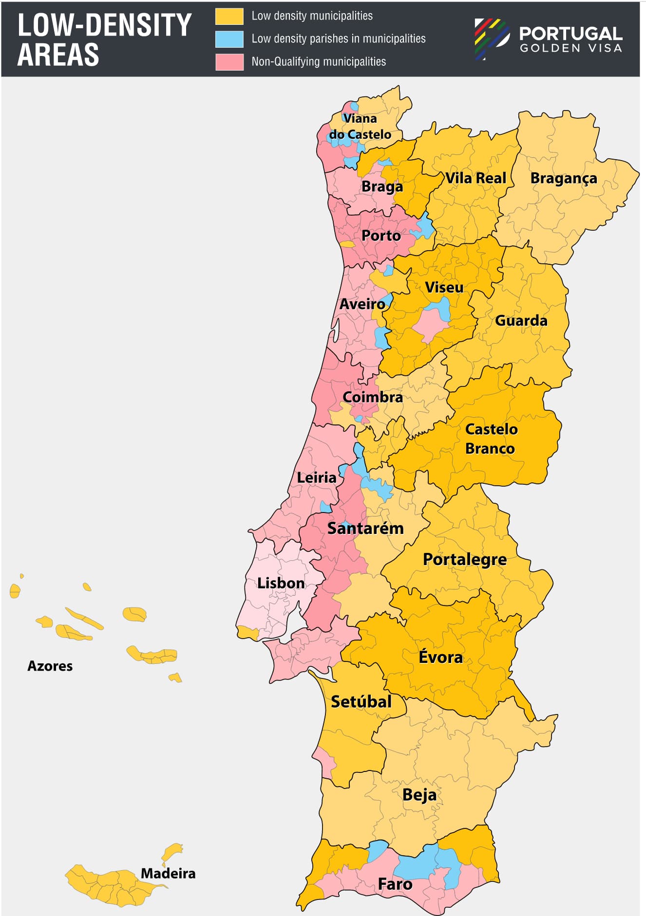
I made the extra effort to include the specific parishes that qualify in the municipalities that other maps often just refer to as “mixed” or “not eligible with exceptions”. Still, I realize the map is not super useful for anyone looking at a specific location/parish in one of these areas, as it can be a bit hard to discern from a map which parishes are included exactly—or even to figure out which parish a given address belongs to.
We’re considering building a simple search tool where you can input any address in Portugal, and it’ll return the status of that specific address (along with information about which parish and municipality it belongs to, if it’s interior or not, etc). Would this be helpful?
EDIT: Here are the regions that the way I read it should qualify as low density currently:
NUTS 3 regions that have lower GDP per capita than 75% (€ 15,523) of the national average (€20,698) (2021 numbers):
2023 Update: The 2021 data is the latest available per January 2023, however in general the population density trend all over the country is falling, so it’s unlikely that any of the ones qualifying in based on the 2021 data would have stopped qualifying by now. Places that could soon drop below the 100 residents per km2 threshold include the Azores (101.8 in 2021) and Coimbra (100.8 in 2021) regions. So it might be worth keeping a look out for any new population data coming out of those places if you would like to invest there.
Hi, The decision is based on the NUT3 level eather based on the GDO per capita and the residents per km². However, the SEF is the SEF and we recommend getting from each municipality upfront the confirmation as the data also changes fast. So the Algarve is based on this criterion a low-density region which was supported by a verdict last year. There you can also see the two criteria as being officially mentioned. I would rather rely on the residents per km² and that is why we also used mainly this criterion in our map.
So glad to have found this community—these answers really help clarify things that were a murky mess in my brain previously! I’m sure all of this becomes obvious once you’re experienced with the process, but as someone new and overwhelmed with information, parts of it have felt incredibly opaque.
Jeff, thanks again for sharing your insights. It’s been so helpful to hear your answer and explanation, and it’s much more than I’ve gotten from any advisor or lawyer so far, so I appreciate having the actual information instead of just taking their word for it!
Thomas, thank you for the map and all the effort that must have gone into it! Will definitely use this as my main reference in the house hunt to avoid another disappointment. From the perspective of someone unfamiliar with this whole process, yes, it would be incredible to have a tool that tells the status of each address. Even better if it has a brief explanation of why the address does or doesn’t work for each category. I imagine something like putting in an Arcos de Valdevez address, and getting a response like:
Residential & Commercial: - approved - minimum: 500k due to being a high-density area, as the NUTS 3 region has over 100 inhabitants per square km (see this link for most recent info) - minimum with renovation: 350k (20% off the standard minimum for the region)
Another thing that I as a newbie would find super helpful would be a map like this where each municipality is clickable for its name. As it is, I’ve been flipping back and forth between Google maps to see a property’s location, maps showing (differing) low/high density areas, and a map with the names of the municipalities listed, then comparing the shapes to try to figure out which municipality is which on the density maps.
Frederik, understood, thank you! That completely makes sense, and explains why your map aligns so well with what Thomas and Jeff have been saying. I’ll actually send you a private message shortly about some of the services Pearls of Portugal offers, if that’s alright.
You know, it might be easier to just use text. the pordata site gives you a nice semi-spreadsheet. sites like idealista generally list both municipality and territory. dump the pordata site as a spreadsheet and look it up.
Yeah, this is pretty much exactly what I have in mind. If we do end up putting this together I’ll make sure to share it here.
I have considered a clickable map as well, as I do have the map created as an SVG file as well, with each municipality and NUTS 3 region as separate vectors. Still, these aren’t properly labeled or anything, so it would require quite a bit of work to finalize—so no promises.
Seriously though, that’s a great idea, and I’ll probably resort to doing it. I’ve stuck with the maps partly because I’m trying to get a sense of what’s where, but your spreadsheet idea should be great at least as a first pass as I eliminate various options. Thanks again for all your help, can’t tell you how much I appreciate it!
That’s fantastic, looking forward to using that tool if/when you end up making it!
And totally understand on the clickable map, of course—it seems like it would be a ton of work. Just figured I’d share what would be useful as a newbie, since I’m sure most of you here are far beyond this stage and may not remember the early baffling days of “Viseu is low density, but Viseu is high density.”
I think it is categorising Azores and Madeira incorrectly. They are both probably non-interior as the tool says but nevertheless should be eligible for residential investment.
Ah, thanks for the heads up! I’ve just been testing with continental Portuguese addresses and got so fixated on getting the interior areas correct, that I completely forgot to add logic to support the fact that residential property investments are indeed allowed in Azores and Madeira, too
We’re looking at buying property in the Azores to qualify for the golden visa, and we’re finding all sorts of conflicting information. Does anyone know whether parts of Sao Miguel island qualify for the reduced 280k/400k Euro residential real estate purchase, or whether all the Azores are in a 350k/500k zone?